Some links on this page are affiliate links. If you click through and make a purchase, we may earn a small commission at no extra cost to you. This helps us maintain and improve this independent guide. Learn more.
Nauru is a raised coral island in the central Pacific Ocean, located just 53 kilometres south of the equator. With a land area of just 21 square kilometres — approximately 6 kilometres long and 4 kilometres wide — it is the world's third-smallest country by area after Vatican City and Monaco, the second-least populous after Vatican City, and the only country in the world without an official capital city. Despite its tiny size, Nauru boasts remarkable geographical features, a unique ecosystem shaped by millions of years of geological activity, and an Exclusive Economic Zone (EEZ) of 308,480 square kilometres of Pacific Ocean.
Location & Geography
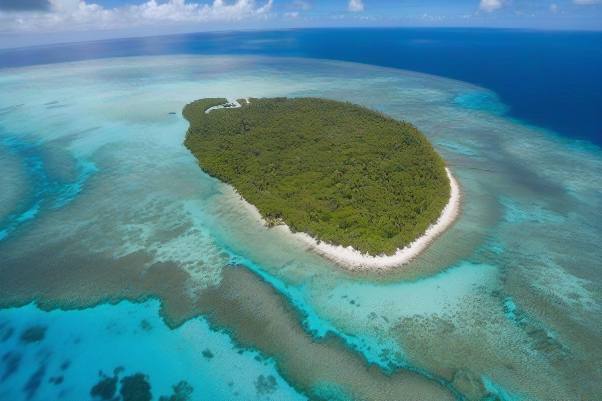
Nauru lies in the Micronesian region of the western Pacific Ocean, northeast of Australia and southwest of the Marshall Islands. Its nearest neighbour is Banaba (Ocean Island) in Kiribati, approximately 300 kilometres to the east. The island is an oval-shaped raised coral atoll — formed when ancient coral reefs were uplifted above sea level by geological forces — and is encircled entirely by a fringing coral reef that is exposed at low tide, creating a natural barrier that has historically influenced maritime access and marine life abundance.
The interior of Nauru consists of a raised central plateau, which is the result of millions of years of seabird guano deposits that transformed the underlying limestone into phosphate-rich rock. This plateau rises to a maximum elevation of 65 metres at Command Ridge (also known as Janor or simply the highest lookout point), which serves as the highest point on the island and offers panoramic views of the coastline and ocean. The plateau is surrounded by a narrow fertile coastal strip, 100 to 300 metres wide, where the vast majority of Nauru's population lives and where most infrastructure — including government buildings, schools, hospitals, shops, and residential areas — is concentrated.
The island has no natural harbour or deep-water port. Small boats can access the island through a man-made ship channel on the western side near Aiwo, and larger vessels must anchor offshore while cargo is transferred via barges. There is one sealed road encircling the island, approximately 19 kilometres in length, which connects all eight districts: Aiwo, Anabar, Anetan, Anibare, Baitsi, Boe, Buada, and Yaren (the administrative centre). Buada Lagoon, a small brackish lake in the island's southwest, is Nauru's only significant body of inland water.
Climate & Weather
Nauru experiences a tropical monsoon climate, characterised by consistently warm temperatures and high humidity throughout the year. Daytime temperatures typically range from 28°C to 35°C (82°F to 95°F), with little seasonal variation due to the island's proximity to the equator — just 53 kilometres south. Night-time temperatures rarely drop below 25°C.
The year is divided into two main seasons. The wet season runs from November to February, associated with the northwest monsoon, bringing heavier rainfall, higher humidity, and occasional thunderstorms. The dry season spans March to October, when the southeast trade winds prevail, bringing slightly cooler and drier conditions — though rain can fall at any time of year, and brief tropical downpours are common. Annual rainfall averages approximately 2,000 millimetres (80 inches), but this varies significantly with the El Niño–Southern Oscillation (ENSO) cycle: El Niño years often bring severe drought conditions, while La Niña years can produce above-average rainfall.
Nauru is located within the equatorial belt and is occasionally affected by tropical cyclones, though less frequently than islands further from the equator. The surrounding ocean water temperature averages a pleasant 28°C year-round, making swimming, snorkeling, and diving possible in any season. The average daily sunshine hours are high, and the UV index is extreme year-round — visitors are strongly advised to use sun protection at all times.
Flora & Fauna
Nauru's original terrestrial vegetation has been dramatically altered by over a century of phosphate mining, which has directly affected approximately 80% of the island's land area. The central plateau — once covered in tropical forest — is now a landscape of jagged limestone pinnacles (known locally as 'topside') separated by deep pits, a terrain so extreme it has been described as resembling a moonscape. However, the coastal fringe retains much of its natural vegetation character.
The island's vegetation includes coconut palms (Cocos nucifera), which line the coast and provide food, oil, and building materials; pandanus trees (Pandanus tectorius), whose leaves are used for weaving and whose fruit is a traditional food source; breadfruit trees (Artocarpus altilis), a staple carbohydrate; and the indigenous tomano tree (Calophyllum inophyllum), a hardwood species prized for traditional carving and boat building. Mangrove forests are found in limited areas along the coast.
Birdlife on Nauru is notable for the island's position on a major Pacific migration route. Species such as the Pacific golden plover (Pluvialis fulva), ruddy turnstone (Arenaria interpres), and various terns and noddies pass through during migration seasons. The Nauru reed warbler (Acrocephalus rehsei) is the island's only endemic land bird — a small, olive-brown songbird found nowhere else on Earth and considered a national treasure.
The surrounding coral reef ecosystem teems with marine biodiversity. Over 150 species of fish have been recorded in Nauru's waters, including colourful parrotfish, surgeonfish, triggerfish, angelfish, grouper, and snapper. Green sea turtles (Chelonia mydas) and hawksbill turtles (Eretmochelys imbricata) nest on the island's beaches, primarily from November to February. The reefs themselves host a variety of hard and soft corals, though some degradation from climate-related bleaching has been observed.
Environmental Challenges
Phosphate mining has left approximately 80% of Nauru's land area in an environmentally degraded state. The central plateau is a landscape of jagged, solution-pitted limestone pinnacles (often referred to as dolomite pinnacles, though the rock is actually phosphatised limestone) separated by deep pits up to 20 metres deep. This terrain — a legacy of stripping the topsoil and phosphate layer — is so hostile to human use that it has been described as uninhabitable. Approximately 20 to 30 years of secondary phosphate deposits remain under current extraction rates, after which mining will cease permanently.
Climate change represents an existential threat to Nauru. Rising sea levels — projected to rise by 0.5 to 1 metre by 2100 under current scenarios — threaten the narrow coastal strip where over 90% of the population lives, along with critical infrastructure including the hospital, airport, Parliament House, schools, and the main road. Increased storm intensity and ocean acidification further threaten coastal communities and coral reef ecosystems on which fisheries depend. Nauru is an active and vocal leader in Pacific Islands Forum climate advocacy, consistently pushing for stronger global emissions reductions and increased climate adaptation funding for vulnerable small island developing states.
Land rehabilitation is a growing national priority. New legislation requires mining companies to restore mined-out areas, and innovative approaches are being explored: filling pits with waste rock and organic matter, regrading the pinnacle landscape, and establishing pilot revegetation projects. The long-term vision is to transform the degraded 'moonscape' of the central plateau into productive land that can support agriculture, forestry, or even future settlement.